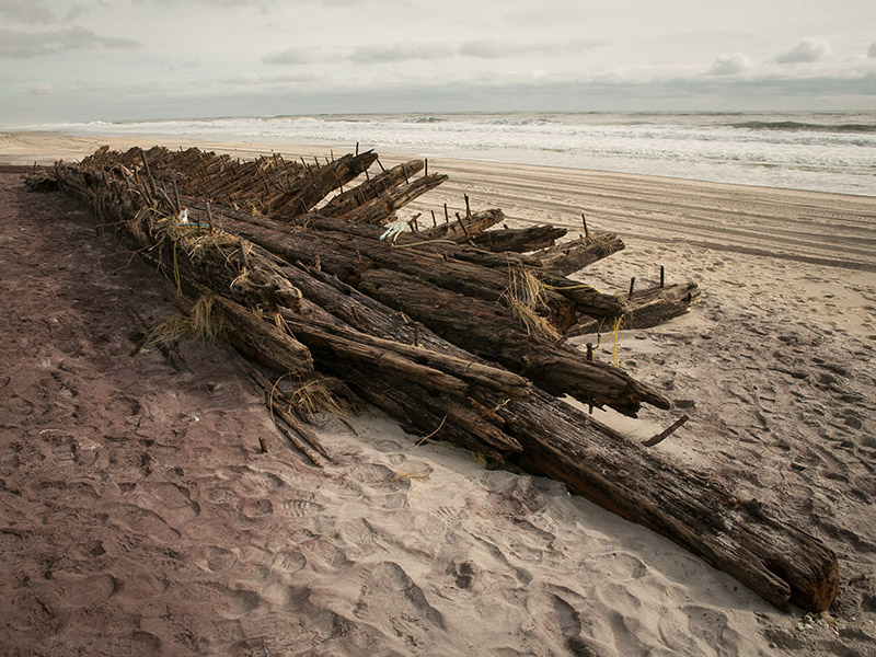
You can find Blue Point Beach about a half-mile west of Fifth Walk in Davis Park. There are only a few houses that are barely visible in the dunes as you stroll along the ocean. The location of the wreck is close to the remains of the old Blue Point Life Saving Station.
History
The Gluckauf was the first “modern tanker,” constructed in 1886, and served as the model for numerous tankers that came after. Despite her name (which translates to ‘lucky’, she had terrible luck when, on March 24, 1893, she ran aground off Fire Island’s Blue Point Beach. She eventually just disappeared into the Fire Island sands. She weighed 2,307 gross tons, measured 300 feet long, and had a 37-foot beam. Only 75 feet offshore, in 25 feet of water, she is currently completely submerged beneath the sand.
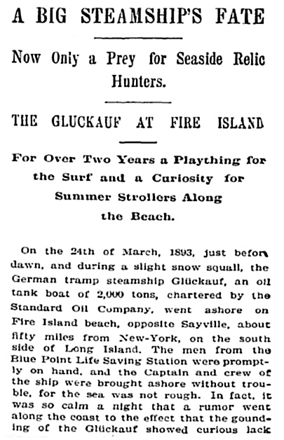
From the New York Times, November 10, 1895
On the 24th of March, 1893, just before dawn, and during a slight snow squall, the German tramp steamship Gluckauf, an oil tank boat of 2,000 tons, chartered by the Standard Oil Company, went ashore on Fire Island beach, opposite Sayville, about fifty miles from New-York, on the south side of Long Island. The men from the Blue Point Life Saving Station were promptly on hand, and the Captain and crew of the ship were brought ashore without trouble, for the sea was not rough. In fact, it was so calm a night that a rumor went along the coast to the effect that the grounding of the Gluckauf showed curious lack of care; she was insured for $200,000 in German companies, and was said at the time to be worth twice that sum. At all events, she grounded on the outer bar and a storm coming up the next day, before wrecking steamers could reach the spot, she was driven, bow on, right to the beach. Had she gone a thousand feet further she would have cut the Blue Point Life Saving Station in two. With her bow clear of the sand, so that a man could walk under her keel, the surf broke over her stern, and, at high tide, all along her starboard side.
The wreck quickly became a tourist attraction, and scavengers ripped up whatever they could and carried it away.
How to Find the Wreck
The wreck of the Glückauf now lies 75–100 feet (23–30 m) offshore, from the water surface to 25 feet (7.6 m) of water.
There isn’t a map with the precise coordinates to show, and it’s difficult to see the wreckage these days. The closest directions we can offer are that you’ll notice a cut in the dunes where cars can enter the beach when you see one of the houses in the dunes. It’s somewhere near there if you stand in front of that cut and take a hundred steps to the east. Low tide is the ideal time to visit. The remaining bow will be easier to see if there are waves and swells.
More information:
wikipedia.org/wiki/Gl%C3%BCckauf_(1886)
www.aukevisser.nl/german/id95.htm